2 Why do earthquakes occur?
What causes the apparently solid and rigid Earth to move and so produce an earthquake? Earthquakes mainly occur when the different blocks or plates that make up the Earth's surface move relative to each other (Figure 2a), causing distortion in the rock (Figure 2b). The distortion builds up very slowly, over tens or hundreds of years. When rocks are distorted very slowly they behave as if they were springs, or pieces of elastic, in being able to store energy when they are stretched or compressed. Prior to an earthquake, the area is like a spring-loaded system waiting to go off. Eventually the distortion is enough to cause the rock to break and move, releasing energy in the form of an earthquake. The break is called a fault. It starts as a small fracture (Figure 2c), but grows rapidly (Figure 2d). In general, the larger the area of the fault, the greater is the size of the earthquake. The fault length (the length of the break along which rocks are displaced) can vary from metres for a small earthquake to about 1 000 km for a very large earthquake.
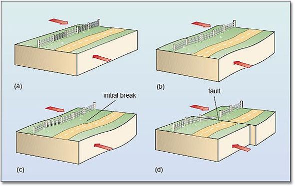
Figure 2 above shows the cause of an earthquake, using block diagrams, illustrating both the surface of the Earth and the Earth in cross-section.
- (a)Part of the Earth where forces (shown by arrows) are trying to move the rock in opposite directions.
- (b)Before a fault breaks, the rocks stretch.
- (c)When the distortion is enough to cause the rocks to break, the break starts at one point
- (d)The break spreads rapidly along the fault, releasing energy. Note that faults are not always vertical, and the forces causing movement can sometimes result in the rocks on either side of the fault moving up or down.
Question 1
Figure 3 is an aerial view of part of the San Andreas Fault in California.
- What is the evidence for a fault in this photograph?
- What are the relative directions of motion of the blocks on either side of the fault?
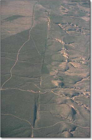
Answers
- The rivers and some roads have been displaced across the fault, which is the linear feature running from the top to the bottom of the photograph.
- The block on the left (southwest) has moved northwest along the fault, and the block on the right (northeast) has moved in the opposite direction, to the southeast. This is deduced from the sense of displacement of the rivers and roads across the fault.
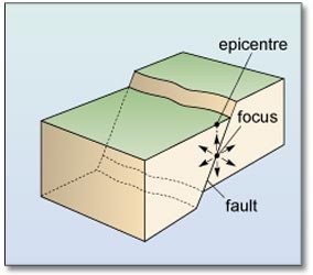
What is the real place of origin of an earthquake? As the initial break propagates, it releases energy along the fault, so in a sense the earthquake originates from the entire fault – which may be 1 000 km long. However, it is useful to refer to one part of the fault as the place of origin of an earthquake, and this is taken as the initial break. It is called the focus (plural foci) of the earthquake. This is usually below (not at) the Earth's surface. The point on the Earth's surface directly above the focus is called the epicentre (Figure 4).
A large earthquake is frequently followed by a series of smaller earthquakes on the same fault, called aftershocks. These can continue for months after the main earthquake. They are caused by readjustment in the positions of the rocks following the main earthquake, releasing smaller, localised buildups of energy on the fault. Sometimes the main earthquake is preceded by one or more smaller foreshocks, although these cannot be identified as foreshocks until after the main earthquake has occurred.
A 1989 earthquake in California had a sequence of aftershocks that revealed the size and orientation of the fault. This earthquake occurred on 17 October 1989 with the epicentre about 100 km southeast of San Francisco, and is usually referred to as ‘the Loma Prieta earthquake’ after the mountain just to the east of the epicentre. The earthquake involved movement on a fault about 40 km in length. It was large enough to cause destruction not only in the nearby town of Santa Cruz but also in San Francisco and its surroundings, where some buildings, bridges and raised roads collapsed.
Figure 5a is an epicentral map (a map showing the location of the epicentres) for the Loma Prieta earthquake and its aftershocks. The earthquake and aftershocks occurred along a well-known fault in California – the San Andreas Fault (shown in Figure 3). Figure 5b is a vertical cross-section of this area along the fault, from point B to point B′ on Figure 5a. This shows the positions and depths of the earthquake and aftershocks, i.e. their foci.
- Over what length of the fault did the aftershocks occur?
- Over about 70 km.
- What was the depth of the main earthquake, and what was the maximum aftershock depth?
- The main earthquake had a depth of 17 km and the maximum depth of the aftershocks was 21 km.
Figure 5c is a cross-section showing the foci on the fault beneath the line joining point C to point C′ on Figure 5a.
- Is the fault vertical?
- No. The earthquake foci become deeper towards the southwest, indicating that the fault slopes down to the southwest (at about 25° to the vertical).
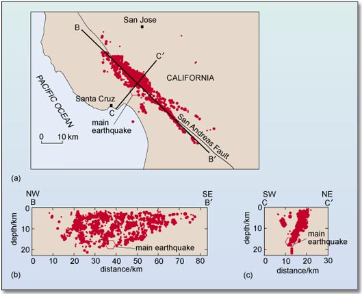
Figure 5 (a) Epicentral map, and (b) and (c) cross-sections, showing the foci for the main earthquake and aftershocks of the Loma Prieta earthquake, California, 1989. BB′ and CC′ on (a) are the locations of cross-sections in (b) and (c), which show foci parallel to (in line with) and perpendicular to (at right-angles to) the fault. Larger earthquakes are shown by larger red dots.
The San Andreas Fault is the largest and possibly most active of many faults in California. As well as the Loma Prieta earthquake, movement along the fault has caused other large earthquakes, including a major San Francisco earthquake in 1906. This resulted in the almost total destruction of the city by fire, following the rupture of gas mains; rupturing of the water mains made it impossible to put out the fires. The land to the west of the fault moved as much as 6 m north relative to the other side during this earthquake.
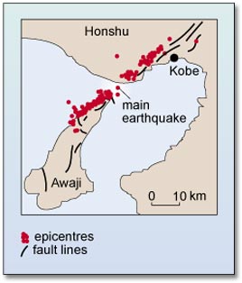
Now we know a bit more about what causes earthquakes, we can return to the first earthquake we considered (Kobe, 1995) to look at it in terms of movement along a fault. The epicentre was about 30 km to the southwest of the city of Kobe (Figure 6). The rocks moved up to 1.5 m horizontally over a 10 km length of a northeast–southwest fault along the northern coast of the island of Awaji. Aftershocks occurred on this fault, and to the northeast, over about 50 km. The only previously recorded significant earthquake along this fault was in 1916, and that was much smaller than the 1995 earthquake. The fault was thought to be moving only very slowly, enough to cause a large earthquake every thousand years or so. Unfortunately for Kobe, 1995 turned out to be the year in a thousand.